
Reading is blessed with two major rivers, the Thames and the Kennet, and several tributaries, including the Loddon and the Pang. We also have brooks such as Holy Brook and Plummery Brook, and a canal that was instrumental in bringing the UK's waterways back from the dead. So, this month, following on from Reading Waterfest, we decided to take a close look at Reading’s relationship with its waterways.
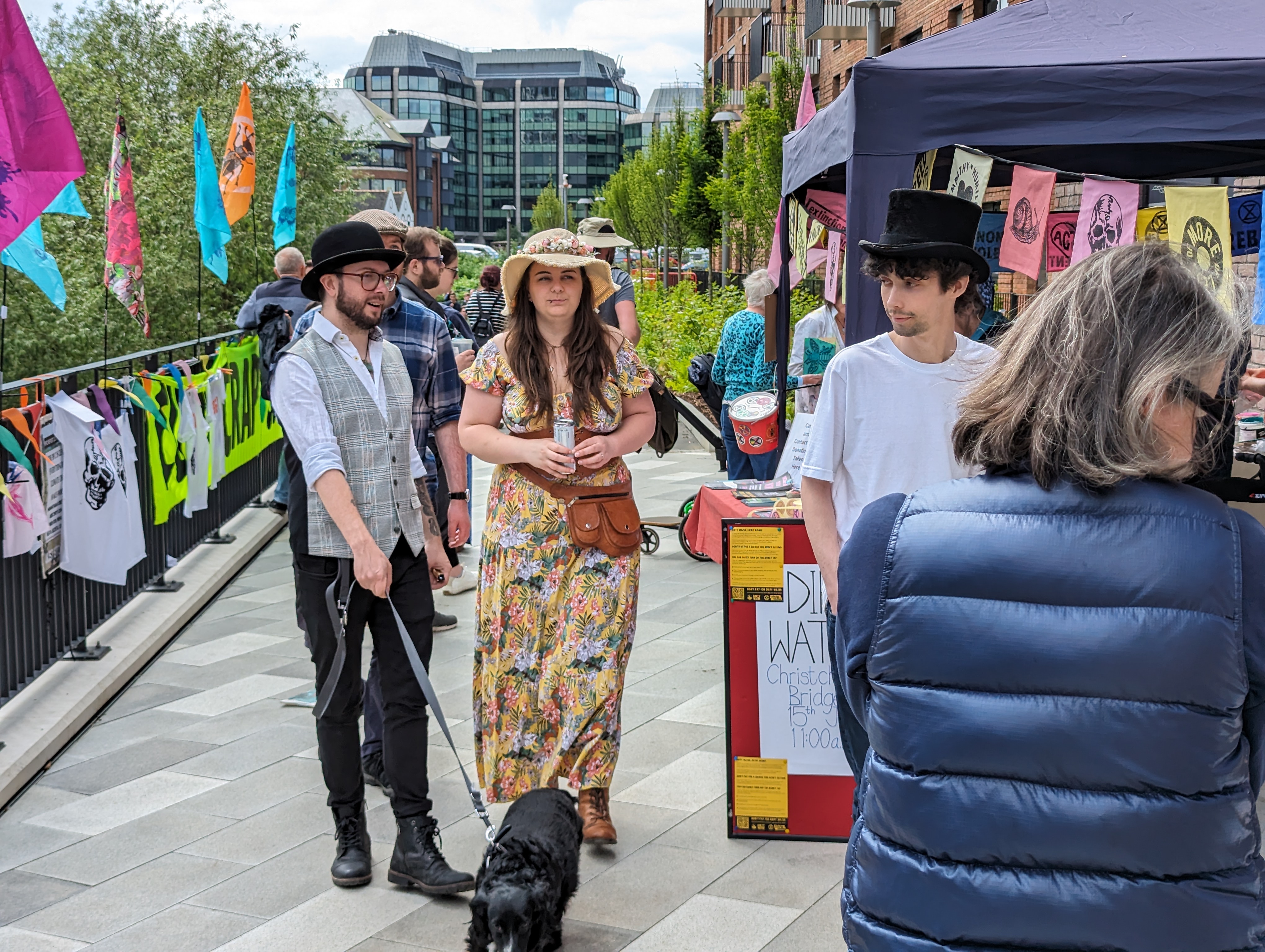
In June, Reading Waterfest was back in full swing after the pandemic and a scorching 2023 event, stretching from Forbury Gardens, through the Abbey, along Chestnut Walk to the new Huntley Wharf piazza.
Originally launched in 1989 to celebrate the restoration of the Kennet and Avon Canal, the festival featured stalls, food, demonstrations, and live music, alongside protests about waterway pollution and the local Ukrainian community, selling beer and food.
The festival highlights the canal’s historical significance with a colorful parade of narrowboats, rides on the river, handmade crafts, local produce, and great entertainment on the open air stage in the abbey.
However, this one day of the year aside, Reading does not by any means make the most of its fluvial assets. Between floods, contamination and traffic problems, the town’s relationship with its waterways remains ambiguous. There are surprisingly few places where you can drink by the riverside - Island has been empty for a decade, the Bel has closed down - there is the rather sterile culvert between the car park and The Oracle, but even there more restaurants are closing than opening.
Even new developments are not enhancing the situation. The units at the lovely new piazza at Huntley Wharf are depressingly empty even as the flats above are full to the brim.
Older Reading residents regale about how they used to go to ‘the beach’ in front of the now nearly derelict Dreadnought near Kennetmouth.
The Local Plan for Reading promotes access to our waterways, yet paths to the river are cut off time and again for 'essential works', the latest examples being at Kennet Side (yet again) and the small bridge at King's Meadow, so even a stroll down to Thames Valley Park and Sonning becomes impossible.
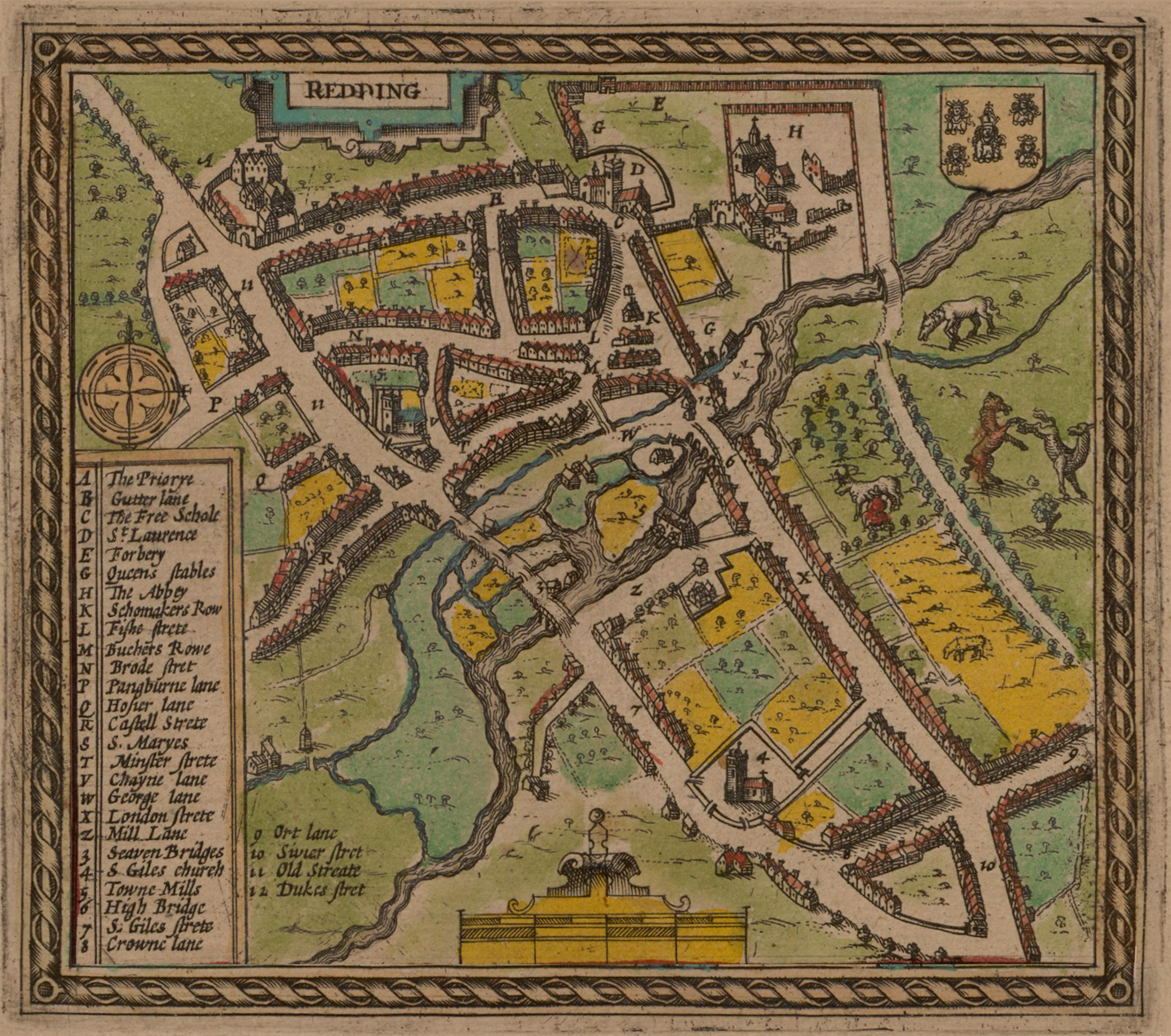
Some History
The Thames, England's second longest river, has been a crucial artery for trade and communication since ancient times. Reading's position on the Thames made it a natural hub for transportation and trade routes. Archaeological evidence suggests that the area has been inhabited since prehistoric times, with the river providing a reliable source of water and food, but also proving to be a danger in times of flood. There is a theory that the name Reading means ‘place of the reeds’.
The Kennet also served as a transportation route, facilitating the movement of goods and people. Roman remains, including villas and pottery, have been discovered along the Kennet, highlighting its importance during this era. The Kennet has always been navigable between Reading and Newbury.
During the medieval period, Reading's rivers continued to be vital. The establishment of Reading Abbey in 1121 by King Henry I marked a significant development.
The abbey was one of the wealthiest and most influential in England and benefited greatly from its proximity to the rivers. The Thames and Kennet provided essential resources for the abbey's daily operations, including fish, water, and transportation routes and there was a flash lock at what is now Blake’s Lock where the abbey charged a fee, generating considerable income.
The town became a thriving centre for the wool trade, with the rivers facilitating the transport of wool to London and other markets. The annual Reading Abbey Fair, held along the riverbanks, attracted merchants and traders from across the country.
The advent of the Industrial Revolution in the 18th century brought significant changes to Reading and its rivers. The Kennet and Avon Canal, completed in 1810, linked Reading to the Bristol Channel, creating a direct water route between London and the West Country. This canal was a crucial development for Reading, boosting its industrial and commercial activities.
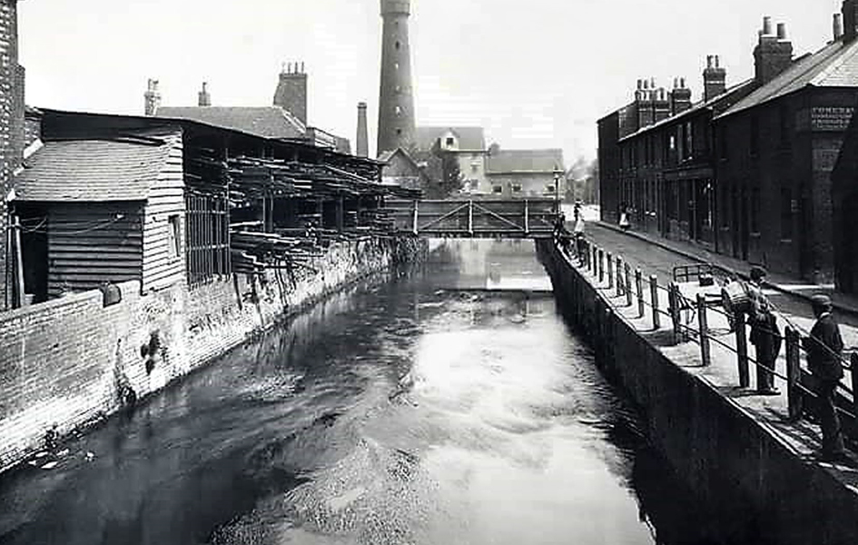
Mill Lane, as it was
The riverbanks became home to numerous factories and mills, taking advantage of the water for power and transport. The brewing industry, in particular, flourished in Reading during this period. Companies like Simonds Brewery, established in 1785, utilized the rivers for brewing and distributing their products.
The River Kennet was made navigable from Reading to Newbury in 1724, and by 1727, boats could reach as far as Bath. However, linking the River Kennet with the River Avon remained a challenge until 1794 when a route was fixed via Devizes, leading to the completion of the canal in 1810. The Kennet & Avon Canal is actually a combination of three historic waterways: the Kennet Navigation, the Avon Navigation, and the Kennet & Avon Canal.
The canal was built to provide a navigable route between the River Thames at Reading and the River Avon at Bath, effectively linking London with the Bristol Channel and it quickly became a vital conduit for transporting goods such as coal, stone, grain, and other raw materials untilt the advent of the railway changed the importance of waterways. Freight was now carried by rail and the railway line itself cut the town away from access to the Thames (even today there are only a few places to traverse the tracks).
Canals all over the UK went into decline, but a determined group of enthusiasts were determined to save and regenerate them.The Kennet and Avon Canal Trust, founded in 1951. By 1990 the Kennet & Avon Canal had been re-opened as a recreational facility. Find out more about this story in the videos below.
The Lost Rivers
Plummery Ditch is a largely lost man-made water course that was used during the Civil War to protect the town. However, viking remains have been found near its banks, implying that the original ditch may have been dug by the vikings to turn the Kennet Thames confluence into a virtual island as they wintered in England in the winter of 870. The course ran between the Thames near Caversham Lock to the Kennet at Kennet Walk. The name refers to the plumb works set up, probably to serve the cathedral and its vast array of windows.
Seven Bridges was an area south of the town centre, roughly where The Oracle now sits, where a number of streams and brooks flowed, many created to feed the many wills along the banks of the Kennet. The river was reasonably shallow here, so easy to bridge.
They included St Giles’ Mill Stream, Grey's Lock Stream, also known as Simonds Ditch, Minster Mill Stream, which originally carried water to the Minster Mill, and Holy Brook.
In 1790 Simonds' Brewery moved to a new brewhouse at Seven Bridges, gradually expanding to take over most of the area.
Today little can be seen of most of the channels that gave the area its name. The Holy Brook still exists; whilst much of it is underground, exposed sections can be found near the St Mary's Butts end of Bridge Street and beside The Blade off Kings Road.
You can find out more about Reading's Hidden Waterways here.
Activities On The Water
So, if you'd like to make more and better use of our best asset, what can you do ? Here are a few ideas.
You can take a leisurely trip on the rivers and canals with Thames Rivercruises from their base near Caversham Bridge or the Kennet & Avon Trust are also offering 45 minute circular cruises on the canal on their boat Matilda Too leaving from the Star Lane Wharf beside the Queens Road car park near the footbridge.
If you're feeling a bit more advenerous you can hire a boat and steer it yourself from Caversham Boat Services on Fry Island.
For the more energetic, you can hire kayaks and paddleboards from Ultimate Canoe, Thames Canoe Hire or Wokingham Waterside Centre .
If you care about the state of our waterways, then you can support ARK.
Also very active about the state of our rivers is the Angling Trust, where you can also learn about how you can take up fishing on our waterways.


Comments
No comments yet. Be the first to share your thoughts.
Join the conversation
Subscribe to inReading to leave a comment.